Trails
The Reserve offers visitors the opportunity to explore its diverse landscapes, including forests, lakes, rivers, and pampas, via distinct trails that can be traveled by car or on foot without a guide.
Routes
Whether you prefer to explore on foot or by car, the Reserve offers a variety of routes to choose from, each with its own unique level of difficulty. This allows you to select the route that best suits your interests and abilities, ensuring that you have an enjoyable and safe experience.
Hiking
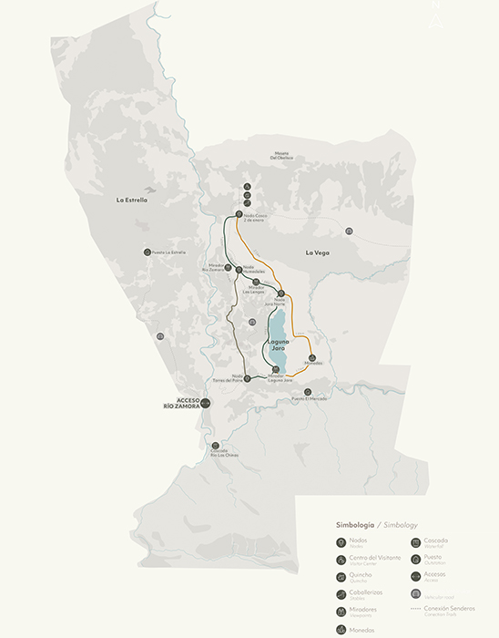
Please note that the Reserve is situated in a remote location, and internet access is limited. To ensure that you’re prepared for your visit, we highly recommend that you download the Suda app prior to your arrival, which contains detailed maps of the Reserve and its trails. This will allow you to navigate the park with ease and make the most of your time here.
Download the map here.
Download the GPS of the route in SUDA here.
Hike / Easy / 3km / 1h40 / bidirectional
Hike that border the Zamora River, passing through forests and pampas, with a constant view of the Paine Massif and a viewpoint that overlooks the steep river valley in the middle of the route.
From the “2 de enero” Node, the trail begins to the south, bordering the wetland by its forest and gradually going down the slope towards the river.
After a mixed stretch of pampas and scattered trees, you enter a dense forest of by way of a narrow path that winds around the trunks and carefully makes its way through the vegetation. The trees provide shade and protection from the wind and invite you to stop, rest and listen to the birds that inhabit this quiet space.
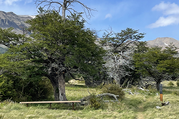
Leaving the forest, the wide canyon of the Zamora river appears by surprise. From a small detour, the trail drops to a bench made of recycled Ciprés wood there to offer a place to rest and observe from above the steep meander of the river, with its turbulent waters coming down and the árboles that cling to its sides.
After the stop, walk south to re-enter the closed forest, which combines open spaces around old trees, with shady tunnels of saplings and scrub. Leaving one of these narrow trails, you´ll face an extensive Patagonic pampa, a contrast from which panoramic views open, especially the Paine Massif that can be seen in its totality in the distance.
It crosses the pampa and ends in a final stretch of forest, arriving at the Nodo Torres del Paine next to the road, from where you can continue towards Jara Lake.

Hike / Easy / 6.1km / 3h20 / bidirectional
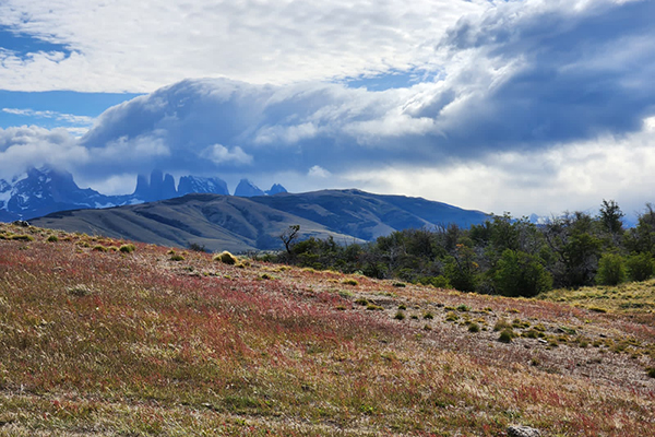
Hike that focuses on showing panoramic views that open towards the Vega, Jara Lake, and the Baguales mountain range.
From the “2 de enero” Node, the trail will start by going around the Vega. This is a place where you can observe birds and animals, like caiquenes, bandurrias, queltehues, chingues, armadillos, and guanacos. The trail will start to climb a hillside that will turn out into a small summit with panoramic views of the entire Reserve, the Vega, Obelisco hill, Jara Lake, etc.
From here the vegetation will gradually disappear and the trail will enter the Patagonian pampa. After a while the grasses are interrupted by the appearance of the Monedas, rock monoliths polished by the wind with various forms that resemble the giant coins. The visitor at this point can circulate between the monoliths The terrain is rocky, covered by yaretas, neneos and various colored lichens.
Once past the Monedas sector, the trail will continue through the pampas until it reaches a small hill, ideal for enjoying the views of the lake, the Obelisco hill, and the Baguales mountain range. Here you can take the forest trail to get out on the road or to return to the start.
Hike / Easy / 5.6km / 3 hours / bidirectional
On this hike you can observe the different varieties of vegetation found on the Reserve. Starting from the “2 de enero” Node, you´ll go up the slope covered in neneos (shrubs)
In the upper part of the climb, you will enter the forests of the Reserve and will be able to see distinct stages of the life of a forest: from saplings, lengas, and mature ñirres, to dead trees that have already completed their cycle. In a forest clearing there is a stop to rest at the foot of some lengas.
Leaving the forest, the trail continues between the west bank of the Jara Lake and the forests of the Reserve. Varieties of birds such as flamingos, caiquenes, queltehues, among others, can be seen in this section.
At the top of a small hill you will find a stop to enjoy the views of the lake, the Obelisco hill and the Baguales range. Here you can take a trail that enters the pampas or finish passing through one last section of forests.